There are hundreds of thousands of artefacts in German museums that were brought to Europe during the colonial era as a result of wars, looting or trade. The history of these objects - where they came from, what they were used for and who once owned ... more
The WorldPop project aims to produce grid-based population estimates up to 2030 broken down by sex and age groups. The overall project is led by Prof. Andy Tatem of the University of Southampton. With this framework, IAPG is responsible for the devel... more
The research network DiViAS brings together previously rarely interlinked methods and practices in the digitization, research and representation of collections from colonial contexts. The project will systematically combine expertise from museum stud... more
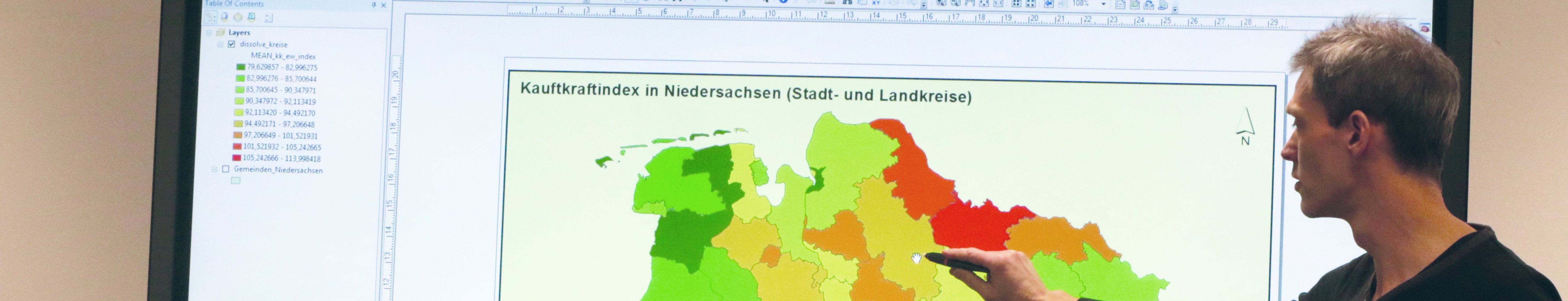
The objective of the project is to evaluate the driving data (time and speed) from a digital tachograph in order to determine the route driven by a vehicle. For this purpose, an application was developed that visualizes an interactively const... more
funded by: Federal Acency for Cartography and Geodesy (BKG)
This is a joint project with the Institute for Photogrammetry and GeoInformation (IPI) and the Institute for Cartography and Geoinformatics (ikg), both from Leibniz University Hannover. It is the first project of the "Gauß Center... more
Transformation and structural change in rural areas mean changes in space and time. Such spatiotemporal data is to be managed and processed by our “Geo-Toolbox”. It uses digital technologies such as databases and geographic information systems &#... more
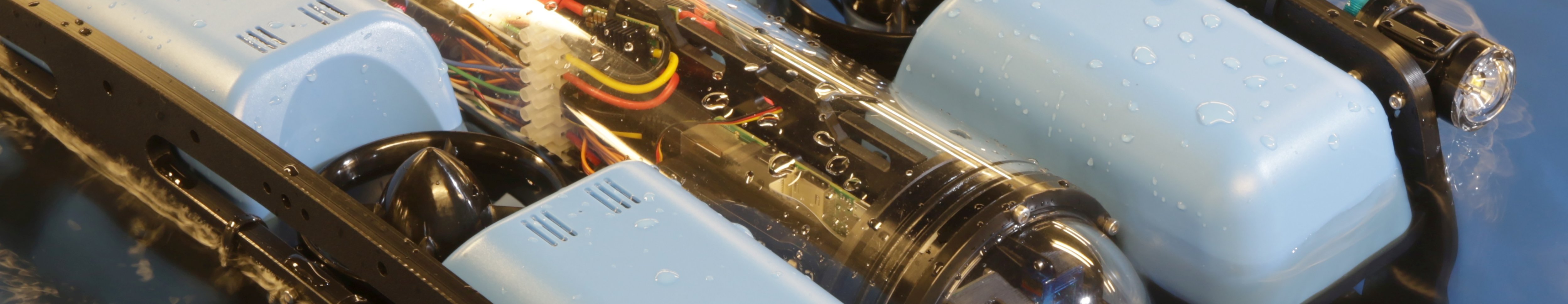
This interdisciplinary project aims to develop autonomous underwater and surface vehicles. One subproject focusses on the development of calibration procedures and algorithms for the special challenges of underwater photogrammetry. Another subproject... more
funded by: Lower Saxony Ministry of Science and Culture (MWK)
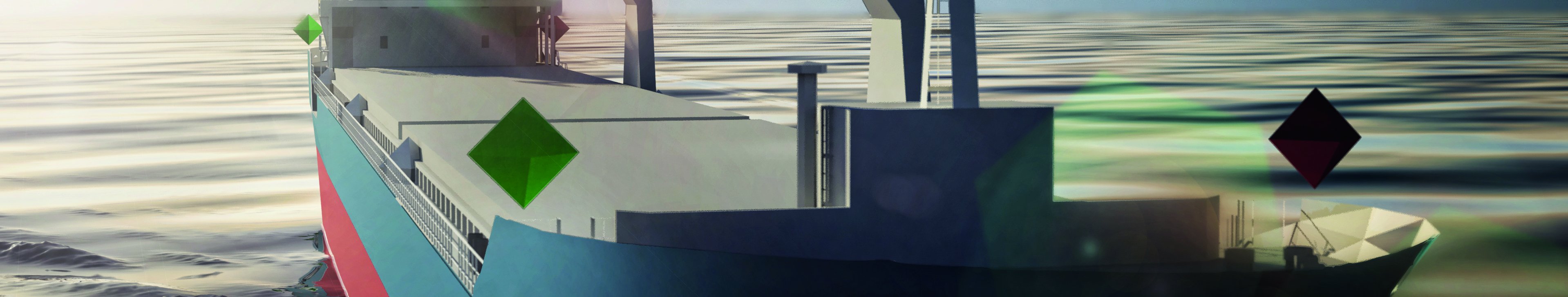
This project aims at the development of the capabilities for a to the greatest possible extent automated detection of small, non-metallic maritime vehicles with satellite-born Synthetic Aperture Radar (SAR). Methods will be applied to the spe... more
The aim of this Ph.d. project was the design and implementation of a system for monitoring of continuous phenomena by sensor data streams. A major focus was the use of methods from the field of geostatistics. more
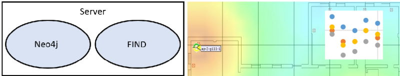
Within the ARDINI project, we developed and evaluated a system of decentralized mobile devices and central GIS applications to increase the quality, efficiency and attractive[-]ness of species collection in the field especially for volunteers. more
In diesem Vorhaben wurden Techniken zur Organisation großer geo[-]referenzierter und spatio-temporaler Mess[-]wert[-]daten[-]banken entwickelt und erprobt.
Ziel des Verbundvorhabens OK-GIS war die Entwicklung und Umsetzung eines Gesamtkonzepts für die Verwaltung, Nutzung, Visualisierung und mobile Erfassung von Geodaten im Rahmen von Geodiensten für das Katastrophenmanagement.
people Prof. Dr. Thomas Brinkhoff
(head)
Galeff Schmees
(02.2008-10.2008)
Christian Rolfs
(10.2005-02.2008)
Ziel des Projekts war die Förderung von Absolven[-]tinnen und Absolventen aus dem Bereich der Geo[-]wissen[-]schaften im weitesten Sinne durch berufs[-]begleitende Seminare im Bereich der Geo[-]informatik.
people Prof. Dr. Thomas Brinkhoff
(head)
Janine Tast
(06.2007-06.2008)
Meike Grotz
(12.2004-06.2007)
Lena Wiegand
(11.2006-06.2007)
Antje Krüger
(09.2004-09.2006)
Axel de Vries
(09.2004-03.2006)
Fernstudienmaterialien Geoinformatik
2003-2010
funded by: Bundesministerium für Bildung und Forschung und Niedersächsisches Ministerium für Wissenschaft und Kultur
Ziel von FerGi war die Erstellung hoch[-]qualitativer e-Learning-Module zu aktuellen Themen der Geo[-]informatik. Am IAPG wurden Module zu den Themen Geodaten[-]standards, objekt[-]relationale Daten[-]banken, Geo[-]daten[-]banken und Geo[-]dienste en...
In diesem Projekt wurde eine Darstellung von Karten als SVG-Dokumente auf mobilen Endgeräten untersucht. Dazu wurde ein SVG-Viewer entwickelt, der auf mobilen Geräten einsetzbar war.
funded by: Europäischer Sozialfonds (ESF) und Europäischer Fonds für regionale Entwicklung (EFRE)
Aufgabe des Projekts war die Förderung des Technologietransfers im Gebiet der Geoinformation insbesondere im Nordwesten Niedersachsens und in anderen Ziel-2-Gebieten Niedersachsens.
people Prof. Dr. Thomas Brinkhoff
(head)
Dr. Daniel Tomowski
(06.2006-08.2008) Stefan Nicolaus
(07.2006-08.2008)
Christine Deike
(06.2006-08.2008)
Lena Wiegand
(11.2006-08.2008)
Axel de Vries
(01.2003-12.2005)
Teleteaching
1999-2000
Im Rahmen dieses Projekts wurde ein multi[-]medialer Vorlesungs[-]raum mit Video[-]kameras, Funk[-]mikrofonen, Mischpult, Laut[-]sprechern, Beamer und White[-]board eingerichtet.
There are hundreds of thousands of artefacts in German museums that were brought to Europe during the colonial era as a result of wars, looting or trade. The history of these objects - where they came from, what they were used for and who once owned ... more
The WorldPop project aims to produce grid-based population estimates up to 2030 broken down by sex and age groups. The overall project is led by Prof. Andy Tatem of the University of Southampton. With this framework, IAPG is responsible for the devel... more
The research network DiViAS brings together previously rarely interlinked methods and practices in the digitization, research and representation of collections from colonial contexts. The project will systematically combine expertise from museum stud... more
The objective of the project is to evaluate the driving data (time and speed) from a digital tachograph in order to determine the route driven by a vehicle. For this purpose, an application was developed that visualizes an interactively const... more
funded by: Federal Acency for Cartography and Geodesy (BKG)
This is a joint project with the Institute for Photogrammetry and GeoInformation (IPI) and the Institute for Cartography and Geoinformatics (ikg), both from Leibniz University Hannover. It is the first project of the "Gauß Center... more